Outside of the main Yosemite Valley region lies a hidden gem for hikers, backpackers, and nature lovers looking to get away from the crowds of Yosemite: Hetch Hetchy (HH). This valley was converted into a reservoir in 1913 and supplies the bulk of San Francisco’s water. Many say that before the valley was filled with water, it was even more beautiful then it’s more famous neighbor, Yosemite Valley. However, even with the valley dammed up, it’s still a very beautiful and picturesque area to explore and is filled with great hiking and backpacking opportunities. The most popular multi-day route in the region, The Hetch Hetchy Loop, provides backpackers with nonstop granite cliff views, cascading waterfalls, and lush forests, all while following the path of the Tuolumne River.
Overview
- Where: Yosemite National Park, California, USA
- Trailhead: Wapama & Rancheria Falls Trailhead | Google Maps
- Distance: 26.5 mile loop
- Time Needed: 2-3 Days
- Elevation Gain/Loss: 6,080 ft.
- Maximum Elevation: 7,610 ft.
- Difficulty: Hard
- Route: O’Shaugnessy Dam – Rancheria Falls – Lake Vernon – O’Shaugnessy Dam
- When to Hike: May – October
- Permits Required: Yes

Map of Hetch Hetchy Loop Trail
Permits
If camping overnight, this hike requires wilderness permits from Yosemite National Park from May-October. Yosemite uses a reservation system for most of its popular backcountry routes, including Hetch Hetchy. 60% of the spots for any given trailhead are reservable, and the rest are available on a “first-come, first-served” basis. Reservations are available 24 weeks in advance on Recreation.gov and the permit processing fee is $10 per application.
The “first-come, first-served” permits have changed for Yosemite National Park since COVID. Rather than being a walk-up permit, they are released on Recreation.gov seven days in advance of the desired start date at 7AM PDT.
The ideal Entry Point for permits on this hike is Rancheria Falls or Beehive Meadows, depending on which direction you do the loop. I did the loop Counter-Clockwise so we got Rancheria Falls permits.
When using the online permit application system, You only need to select the start date of your hike. Later in the application process you specify how many nights in the backcountry you will be and rough estimates of where you plan to camp.
The permits must be picked up in person at a wilderness center one day in advance (8AM to 5PM) or on the same day (8AM-11AM). The easiest place to pick up the permits for Hetch Hetchy is at the Hetch Hetchy Entrance Station.
How To Get There
Hetch Hetchy is located outside of the main Yosemite Valley area to the north and not directly reachable from the valley. Hetch Hetchy is about an hour and a half drive from Little Yosemite Valley and requires exiting and re-entering the park at the Hetch Hetchy Entrace Station. The gates to the Hetch Hetchy road are open from 7AM to 9PM on May 1- Labor Day. For dates outside this window and road conditions click here.
Overnight parking is located at the Wapama & Rancheria Falls Trailhead for free to backpackers. Also, backpackers are able to use the backpacker’s campground for one day before and after their trip for $8 per person for each night you use. The backpacker’s campsites are first-come first-serve and on the honor system for paying the fees with the provided envelope (bring exact change!). The campsites in the backpackers campground include a food storage locker and picnic table, with water about a 10-15 minute walk away.

Trip Report
I did this trail with my friend Charlie on May 27-29, 2019, but have recently updated this post to be more thorough and include the latest permit information. The snowpack in 2019 was at record levels and changed our original plans from backpacking Mineral King in Sequoia National Park to instead backpacking the Hetch Hetchy Loop.
When we picked up our permits from the Hetch Hetchy Entrance Ranger Station, the Park Ranger told us to expect up to 4 feet of snow and jokingly asking us if we brought our galoshes (rubber rain boots). Or maybe he wasn’t joking, because they would have been nice as you’ll see later on in this post! We bought trekking poles and microspikes before the trip in preparation for potential snow hikes. The trekking poles were an excellent investment and I don’t know if we would have made it through safely without them, but we never used the microspikes. Microspikes are good for hard packed snow and ice, which we were expecting, however we were the first ones to do the Hetch Hetchy Loop after some decent snow a few days earlier, so the snow wasn’t packed at all.
Day 1
Yosemite Valley is somewhat on the way to HH so we stopped there first to check out a few of the iconic sites, pick up our wilderness permits and rent a bear canister.


HH was about an hour drive from the valley. We did some last minute packing and divvying up the food (cheez-its were our nectar) and then we were ready to begin our 3 day trek!


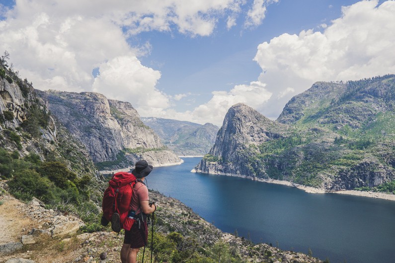
The backpackers parking area is a decent walk to the start of the trail, maybe 3/4 of a mile and all downhill. When we got to the dam, we had nice views of the reservoir and a few waterfalls. Wapama Falls was deceivingly far away. I thought it’d be a quick hike to get there, but it was 2.5 miles away and took over an hour.

Once we got there, the falls were raging and the mist was refreshing.


After stopping for a quick lunch before leaving the reservoir area we met some trail friends, Jeremy and Becky. We hiked together for a few miles but then split up after Rancheria Falls, which was around 5.5 miles from the trailhead.


Rancheria Falls had lots of nice campsites, and sleeping next to the sound of rushing water would have been great. However, after examining the map, Charlie and I decided to push on to knock out some elevation gain for day 2. Looking back, both of us are really happy we made this decision, especially after a challenging day 2 with lots of snow trekking.
We climbed over 1000 feet in a mile and a half after the Rancheria Falls and entered the clouds. It was exhausting and we were desperately looking for anywhere to camp. We ended up finding a flat spot in a boulder field off of the trail and near a creek. It didn’t look like anyone had camped here before (so no fires), but it was a pretty cool spot.

We set up camp, ate some dehydrated Fettuccini Alfredo with Chicken from Backpackers Pantry (which was surprisingly good) and called it a night pretty early. I got up around 1am to pee, and the clouds had dissipated and the milky way was bright! I also saw a lot of meteors! I ended up waking up Charlie so he could see it as well and persuaded him to help me do some astrophotography.

Day 2
The next morning we gave our gear a chance to dry out before departing. It didn’t rain, but all of the moisture from the clouds made it damp.

Our next landmark was Tilltill Valley, about 1 mile from where we camped on night 1. We were very glad we brought sandals to switch into because the trail went through a large boggy area with water up to our knees. I’m not sure if it’s always this boggy, but I feel like it probably is.


Next was the big climb for day 2. About 2000 more feet to get to the high point of the loop, 7650 feet. We were definitely starting to feel the air getting thinner as we ascended because we both live at sea level elevations. As we approached 7000 feet, the snow was starting to become a lot more prevalent.


And soon, we lost the trail…


The 4 feet of snow estimate from the park ranger turned out to be a massive understatement — we were hiking on snow drifts up to 10 feet tall. We were also sinking into the snow at least a foot with every step. Snowshoes would have been great to have, but instead we had cold soggy hiking boots.

It was interesting trailblazing through the snowfields constantly looking for signs of a trail. I don’t know why the NPS doesn’t have trail markers on this section of the loop, because they do on most of the day 3 section of the loop.
I have an app on my phone called Topo+, which is topographical maps synced with your GPS, and I downloaded the HH area for offline use for the trip. It’s practically a modern orienteering device. The app saved us multiple times when we wandered off trail in the snow. We actually followed deer and bear tracks frequently through the snow because they seemed to be following the trail. The animals probably do follow the trail considering the forest is pretty dense and the trail is a nice footpath for animals.
We took turns leading in the snow and the person behind would step in the other’s footprints to save energy. A big struggle of hiking through the snow drifts was avoiding postholes (loose snow near fallen trees or above melt areas). Snow around the fallen trees would collapse under our weight and our legs would fall through, up to hip deep at times. We would use our poles to poke around ahead of us to check if the snow in front of us was packed enough to walk on. It was an ACL/MCL spraining nightmare but we managed to escape with no knee injuries. Charlie did however fall through a posthole and got scraped by a tree branch which turned into a massive bruise; luckily the stick didn’t pierce through his leg. I also had some very tender Achilles tendons the next morning, and was limping around for a few days after completing the loop.

Snow trekking also required us to have to cross some snow bridges over creeks. Both my legs fell through, but my backpack stopped me from falling all the way through. It was very terrifying and I ended up crawling out on my belly very quickly.

After about 3 miles wandering around in the snow we finally found a section of solid ground where we could rest. Charlie let out a primordial grunt when we made it: “OOGA BOOGA!”, and that became one of our catch phrases for the rest of the 2 week trip. I also unfortunately left my favorite pink Nalgene water bottle at the rest site. I’m guessing we were pretty far off the actual trail so I wonder if anyone will ever find it.
After leaving the rest spot, the snow disappeared rapidly and we made our way to a very rocky area. We spotted a large solo cairn off in the distance and were finally back on a trail! That cairn is definitely the most helpful and happiness inducing cairn I’ve ever come across on a hike.

We were once again in a cloud, and camped on the northeast side of Lake Vernon. I would say the north side has better views and campsites then the south side near the main trail but they’re both nice. The south side has the advantages of being near the creek, and not having to hike an extra half mile.
On night 2 we ate meat lasagna from Mountain House, and threw some of the cheez-its in for a delicious meal on night 2. We also split a dehydrated ice cream sandwich, which tasted just like a normal ice cream sandwich, but super crunchy and not cold. As we were eating, the clouds opened up a bit and we got some nice cotton candy looking clouds around the lake. A curious mule deer also wandered into our campsite and we had to shoo it away.


While we were setting up camp a boy scout troop arrived and set up camp in the same area. After chatting with one of the group leaders, we learned they got lost in the same snowdrifts and ended up finding our footprints and that’s how they made it to the lake. They were confused when they saw 2 of us but only one set of tracks haha. Charlie and I definitely felt like some true wilderness explorers.
Day 3
The next morning we had damp gear again due to the low clouds and let our gear dry out while eating breakfast near the lake. We saw a lot of salamanders near the shore and they were very entertaining to watch. It was like natural television out in the backcountry.


Day 3 was very chill and almost all downhill. It was about 11 miles back to the campsite and we did it in under 6 hours. We pretty much only stopped for lunch and to filter our water from creeks a few times. The last 4 miles on the beehive trail were quite steep and had a lot of switchbacks. While descending, we passed some people about 2 miles away from the main trail and they looked exhausted and still had a long way to go. It would be a very strenuous endeavor to do the loop clockwise and make it all the way to Lake Vernon on Day 1.
The last mile of the loop had some of the best views. Seeing the reservoir from a higher elevation was a beautiful sight after hiking through the pine forests most of the day.
Overall this was a challenging, but fun loop. Large amounts of snow so late in the season made the hike pretty unique and it was also both Charlie and my first time backpacking in snow. The loop definitely would have been more enjoyable with snowshoes, and even more enjoyable with a lot less snow. If you want to do the Hetch Hetchy loop I recommend doing a similar itinerary to what we did and to definitely go counter-clockwise.
Related Blog Posts

Best Hikes Near Washington D.C. – From a Local
Updated for 2024! I've lived in Northern Virginia for over 10 years. I've had a chance to explore the iconic hikes near Washington D.C many times. And when I say near D.C., I mean around 2 hours or less. The DMV is a majorly sprawled metropolitan area; so aside from...

The Complete Guide to Backpacking from Tenaya Lake to Yosemite Valley
Backpacking from Tenaya Lake to Yosemite Valley is one of the premiere multi-day hikes in the United States, and also one of the most sought-after for permits. Throughout the hike you get to walk among towering granite rocks, feel the mist of several of...

Backpacking Paintbrush Canyon – Cascade Canyon Loop
Grand Tetons National Park September 6-7 , 2021 Overview: Distance: 21.5 miles Elevation Gain: 3656 ft. Time: 2 days, 1 night Difficulty: Strenuous Camping overnight in the backcountry of GTNP requires permits from the NPS. This includes Backpacking Paintbrush...

Backpacking to Hole in The Wall | Olympic National Park
Overview: Distance: 3.4 miles Time: 2 days, 1 night Difficulty: Easy Backpacking to Hole in the Wall is a fun easy overnighter (or day hike) that provides some beautiful views of the Oregon Coast. There’s towering rock formations in the shallows, dense forest...

Great journey. Thanks for the information.
Thanks for reading!
Thanks for sharing all these details! This is super helpful for our planning.
No problem Tara, glad it was useful to you and thanks for reading and commenting!
Hi there, I’m hiking Hetch Hetchy this summer. I was wondering if there are any rock scrambles and if you have any advice on training for this hike.
The last section of the hike is completely scree, so lots of rock scrambling. But other than that, it is just a well-maintained trail with a lot of switchbacks.