
Overview
- Where: Banff + Mount Assiniboine Provincial Park, Alberta, Canada
- Trailhead: Healy Pass Trailhead | Google Maps
- Distance: 60 km Point-to-Point (37.5 miles)
- Time Needed: 3-5 Days
- Elevation Gain/Loss: 2480 m (8146 ft)
- Maximum Elevation: 2384 m (7,822 ft.
- Difficulty: Moderate
- Route: Sunshine Meadows – Citadel Pass – Lake Magog – Marvel Lake – Mt. Shark
- When to Hike: July-September
- Permits Required: Yes

This past October, I embarked on one of the most beautiful backpacking trips of my life, tackling 37.5 miles and 8146 feet of elevation gain over the course of four days. While that may sound intimidating, the trail was fairly moderate, with most of the elevation gain being gradual other than a few strenuous sections.
I had always dreamed of visiting the Canadian Rockies, and when I finally made it there in 2017, I knew I had to come back in the fall some day for the legendary Larch Madness. During this brief climate window, all the larch trees in the area (which closely resemble Christmas trees) turn a vibrant yellow. I was lucky enough to convince my adventure friend group to go to the Canadian Rockies for our annual outdoor adventure trip. We timed our visit for backpacking Mount Assinboine perfectly, arriving on the first weekend of October 2022, when the larches on this particular trail were at their peak. Other popular trails, like Sentinel Pass and Larch Valley, had already passed their prime and were a darker shade of yellow.

This trek came with a number of logistical challenges, especially in the off-season. For one, it’s a point-to-point trail, so you need either two cars or a shuttle to get between the two trailheads. We opted for the shuttle option, using the Three Sisters Taxi Service, who were fantastic and I highly recommend them. They picked us up from the Mt. Shark trailhead at 8 am and dropped us off at Sunshine Village.


There are six backcountry campsites along the trail, which makes it easy to tailor the trip to different skill levels. Initially, we had planned to complete the trek in three days, but after an intense two-day backpacking trip in Yosemite earlier in the summer with some of the same crew, we decided to add an extra day for more relaxation and to really soak in the stunning scenery. In the end, we spent four days and three nights on the trail, with no day being longer than 12 miles.
In the summer, hikers can opt to take the Sunshine Gondola to the top of Sunshine Mountain to begin this particular trek backpacking Mount Assiniboine or explore other popular hikes in the area (like Healy Pass or Citadel Pass). I’m not sure when the gondola typically closes for the season, but comments on AllTrails indicated that it had already shut down by mid-September this year. This added an additional 3.4 miles and 1700 feet of elevation gain to the start of our trip, as we had to hike up the service road to reach the ski village at the summit. Luckily, this was probably the most difficult part of the trek and I’m glad we could knock it out at the beginning when we had fresh legs.
Day 1 – 11.5 miles
After reaching the top of Sunshine Mountain, we set off on the “real” hike, starting with Citadel Pass. This trailhead also marked the crossing from Banff National Park into Mount Assiniboine Provincial Park. The first few miles on Citadel Pass were fairly flat, with just one moderate section of elevation gain, and we also got our first glimpse of dense larch tree patches.


On the other side of the ridge, the explosion of yellow larch tree colors simply blew my mind. I had no idea this trail would offer so many Larch madness viewing opportunities, competing with the more popular larch hikes in Banff. Howard Douglas Lake was our potential Day 1 campsite if we were too tired from the service road ascent (and we got a permit in advance), but we felt well enough to press on, so we just stopped there for lunch. I will say, though, that this was a much nicer campsite than the actual campsite along the trail where we stayed, and it was by a lake.


After lunch, we faced another moderate section of elevation gain before a pretty rapid descent into the valley where the Porcupine Backcountry camp was located. The descent was approximately -2,000 feet of elevation loss over 2.5 miles. Bless the knees and toes!
The Porcupine campground was situated at the bottom of the valley between two crossing streams. One of the streams was dry, while the other had a light flow. This was the case for most of the hike – I’d say only about 50 percent of the streams were flowing, but there were still plenty of opportunities to refill our water bottles. All of the backcountry campsites were really nice, with pit toilets or outhouses (shielded from the weather), bear boxes to store food, and cooking areas with benches or wooden picnic tables.
I didn’t have a thermometer or cell service to check the weather forecast for all three days of the trek, but it was definitely chilly at night, with lows in the low 30s or upper 20s Fahrenheit. As expected, the mornings, right after sunrise, were the coldest parts of each day. This definitely wasn’t ideal, as no one wanted to crawl out of their cozy sleeping bags.
Day 2 – 9.5 miles
On Day 2, we set our sights on the Mount Assiniboine area. We hadn’t really seen the peak since the top of Citadel Pass, nine miles earlier. And that trend continued.
Day 2 was a bit of a slog, mostly uphill. The day started with a more serious incline, and the first four miles were spent switchbacking through the forest with no views and no larch trees.
Eventually, we popped out at Og Lake, where we stopped for lunch and refilled our water bottles. Sour Patch kids never tasted so sweet. Og Lake is also a very nice camping spot with elevated views of the lake. However, it’s important to note that there’s not an easy path to the lake from the tent pads – it would probably take a five to ten minute walk to get down to the water.


After lunch and departing Og Lake, we entered a classic high alpine tundra area, where the plant life and scenery totally changed. We could finally see Mt. Assiniboine again! The next several miles, once we entered this tundra area, were fairly flat until we reached our Day 2 camp at Lake Magog.
We were all pretty disappointed by the Lake Magog campsite. And unfortunately it’s the only option in the area, so there’s really no other choice unless you book a cabin stay. While there was a beautiful view of Mt. Assiniboine, Lake Magog was completely obstructed by a lot of elevated land between the tent pads and the lake shore. To get down to the water required another 15-20 minute hike and around 300 feet of elevation descent, which we had to do because the water pipes at the tent pads were also shut down for the off-season.
The view down by the water was great and worth the hike!


We had three photographers on this trek, and we were all having a blast photographing Mt. Assiniboine as the light faded during sunset. We also got up in the middle of the night to do some astro photography of the peak. Unfortunately, we missed the iconic photo spot at Sunburst Lake. We didn’t realize until after we completed the trip that this spot was off our main route – we thought we would just stumble upon it at some point while hiking. That wasn’t the case 🙁 But that just means we’ll have to return!

Day 3 – 11 miles
On the third day, we woke up to some beautiful, chilly weather and decided to take it slowly. After making coffee and eating some snacks for breakfast, we headed back to the lakeshore trail to see Mt. Assiniboine in the morning light and take our annual group photo.


Also shoutout to Ian waking up earlier than everyone and capturing some photos of a black bear down at the shore of Lake Magog.
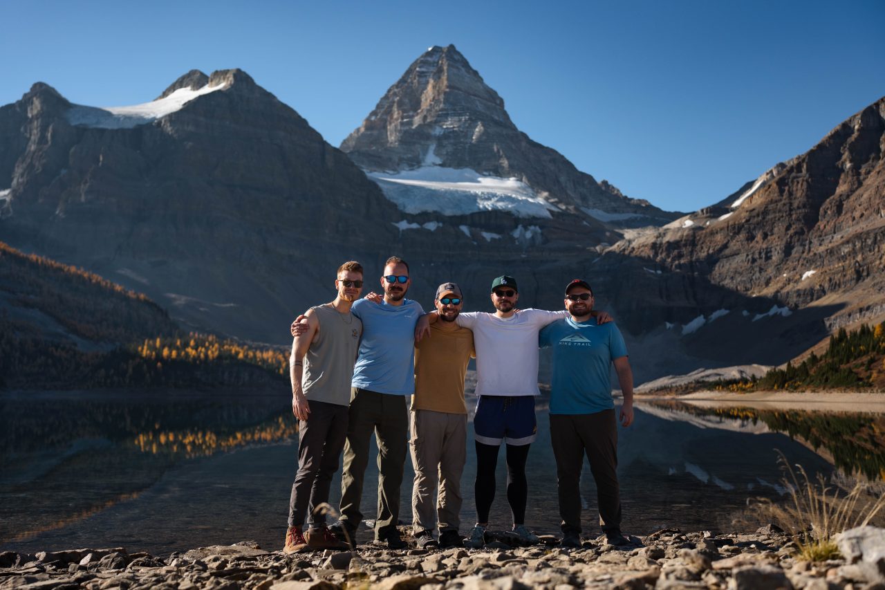
Love these dudes!
After leaving the Lake Magog area, we entered an extensive Larch Madness area. The trees were a tad past peak and more orange than yellow, but we found ourselves surrounded by an ocean of larches. This area had more larches than other tree species, which was the opposite ratio of what we had seen the previous two days.
We remained in the magical larch forest for the first two-mile ascent. The switchbacks were a bit intense at times during those first two miles, but the views were excellent for distracting us. Wonder Pass was the highest point of Day 3, and then we began an eight-mile descent. We had distinctly different views after reaching Wonder Pass and entering a new canyon.


The first mile of descent after Wonder Pass was fairly gradual. We saw a grizzly bear about 100 yards ahead of us just off the trail for about two seconds before it disappeared into the forest. We waited about 10 minutes to continue, pulling out our bear spray to be on the safe side, making loud noises, and proceeding with caution. We never saw it again.
After we got our first glimpse of Marvel Lake, the real descent began. It was about 1,500 feet of elevation decline in about 1.5 miles. This section is the main reason I’d recommend going the direction we did, instead of Mt. Shark to Sunshine Village.


The scenery shifted dramatically again, and it felt like I was transported back to my summer backpacking trips in Banff in 2017. We were treated to views of a giant turquoise glacier lake, majestic mountains, dark green pines, and almost no sign of larches. After crossing Wonder Pass, we were actually back in Banff National Park, but it was interesting how all the larches disappeared so suddenly.
Even after reaching the bottom of the switchbacks, we still had three miles to hike parallel to Marvel Lake, still about 500 feet above the shore. It felt like the lake was growing as we hiked these three miles. The lake is so massive that the views barely changed even though we were making forward progress, and it seemed like the end of the lake would never come.
But it did, and we all dipped our legs in the water. I really wanted to swim, but the sun was starting to set and I was worried I wouldn’t be able to dry off fast enough before the night time chill arrived. A short hand slapping bath with the ice cold water would have to do.
Like the Og Lake and Magog Lake Campgrounds, the Marvel Lake campground is not close to the lakeshore. We were originally planning on camping here but instead felt the need to push on to the Br9 to make Day 4 shorter, because we realized we made a major goof.
We way under-packed our food. This was our first 4 day backpacking trip; in the past we mostly did 2 day adventures. When we were packing food, it looked like double what we normally packed and none of us questioned it. Oops. We weren’t completely out of food yet, and as long as we finished in 4 days as planned we’d be fine, but hungry.
The Marvel Lake Campground and Br9 campground both have nice creeks running through them for water. The cooking area at the Br9 campground was much further from the tent pads than all of the previous campgrounds we stayed at on the trek. I’m not sure if it was because we were in Banff National Park now instead of MAPP.
Day 4 – 5.5 miles
For breakfast on Day 4 we skipped the coffee and had our remaining snacks to fuel us for the last 5.5 miles. Cheez-its, trail mix, and skittles… breakfast of champions, hahaha.
The last 5.5 miles were mostly flat and through forests with no views. We did have one amazing view though towards the beginning of the day at a river crossing that fed into the Spray Lakes. We did this hike pretty quickly, in about 2.5 hours. Then we packed up the car and booked it to the Wendy’s in Canmore to feast.


Summary
Sunshine Meadows to Mt. Shark is a 10/10 4 -day backpacking trek and fairly moderate. There were a few intense sections, but overall the elevation gain and descent were fairly gradual over the 38 miles, with the main difficulty just being the sheer distance/time on our feet.
I’m sure this hike is very beautiful in the summer, but hiking through the yellow larch forests in early October was absolutely gorgeous and unforgettable. Even when I was out of breath, I still had a big smile on my face throughout all the larch sections.
I’ve done several backpacking trips in the Canadian Rockies and this is my new #1. I would love to return and do this trek again in the future. Next time, I’d love an opportunity to see the mountains blanketed in fresh snow and dotted with bright yellow larches.
As a bonus, I’m linking a map below with a lot of popular fall color hikes in the Banff National Park region. When I was doing research for this trip I put them all on this map, many with links to corresponding blog posts. It’s mostly day hikes, so maybe a combo with this trek??

Hey Tristan, how much did the taxi service cost from Mount Shark to Sunshine Village?
$350 total, and they could only take 4 of us.